 In Harris County, Texas (which is approximately the City of Houston), for the November 6, 2018 election, I was appointed an “Alternate Judge” to help oversee the voting process for a precinct.ª
Because the ballot for each precinct is different, the complexity of the whole set of registrations, election districts, and results data for Harris County intrigued me, so I did what I know how to do best[1]: I developed a “conceptual data model” to try to simplify that complexity.
I hereby submit, in two parts, my conceptual data model of the election process—at least as I experienced it in Harris County, Texas. I am told that the other large counties in Texas, (Austin, Dallas, etc.) use the same technology, at least in the election equipment. Moreover, here I make extensive use of my patterns, so I am trusting that, while I cannot prove it, the concepts described here are widely applicable.
The conceptual data model presented here is similar to a database design, but rather than describing database objects (like tables), it represents the things that are of significance to the problem. This model is not concerned with the voting equipment, software, or organizations. Rather, it is a series of representations of how the individual precinct ballots are constructed and how registered voters come to use them.[2]
This is the first of two articles. This article sets the context…
- Geopolitical Areas – the way a bounded neighborhood precinct overlays various voting districts, including congressional and state representative districts, among others.
- Precinct Structures – How a precinct is related to all its overlapping districts
- Precincts and Streets – How a prospective voter’s address may be found in a particular precinct.
Article 2 will fill in the details…
- Voter Registrations – How each potential voter is recorded and connected to a precinct
- Candidacies – How a candidate for an office (or a ballot measure) may be shown relative to the district ‘e (or it) represents.
- Elections – How ballots are selectively defined for each precinct.
- Voting Sessions – How a vote may be recorded for each candidate (or ballot measure).
The Problem
To provide a context for this model, understand that the election process in Harris County is carried out in two parts.
The first is controlled by the Harris County Tax Assessor Collector and Voter Registration Department. The Voter Registration portion of that Department is responsible for registering as many eligible people as possible to vote, and maintaining the registration data for use in elections. Also maintained here are the definitions of election districts and their relationships to the neighborhood precincts where the voters live and vote. The result of this effort is a compilation of all eligible voters by precinct, as well as templates for the ballots used in each precinct. The maps of the precincts and voting districts are maintained using software from the Environmental Systems Research Institute (known as “Esri”), and the registration records are maintained using software from the VOTEC Company.
The second part is the actual conduct of the election, controlled by the Office of the County Clerk. On election day, each person wishing to vote is screened in terms of h’ identification and registration, and then provided with a voting booth that carries the ballot appropriate to h’ precinct. The ballot “templates” would have been obtained from the County Tax Assessor’s Office. The results are captured on the Hart InterCivic Equipment, and at the end of the day, booth controllers are physically transported to a central location for tabulation.
The logic presented here, by definition, describes the work to be done by these software packages and equipment, but I have limited knowledge of how either of them works. Most significantly, I do not know how they are connected to each other.
About the Notation
First a word of explanation about the data model notation used here. It was developed by Englishmen Richard Barker and Harry Ellis during the 1980s. The approach is remarkable in that it represents the nature of a problem, without respect to any technology that might be used to manipulate it. Specifically, each box represents an “entity type”, defined here as “a category of things of significance”. Each relationship is defined to be represented by two simple assertions, each in the form <subject> <predicate> <object>.
In the following article, you will see each relationship is in the form:
Each
<FIRST ENTY TYPE>
must be (solid line next to first entity type)
<or>
may be (dashed line next to the first entity type)
<relationship name>
one and only one (no special character next to second entity type)
<or>
one or more (a crow’s foot (“>”)next to second entity type.
<SECOND ENTITY TYPE>
Two additional notes about the notation:
- “Sub-types” are entity types that are sub-sets of a “super-type”. For example, in Figure 2 below, precinct is a sub-type of geopolitical area. That is, every instance of precinct is, by definition, also an instance of geopolitical area. Other sub-types of geopolitical area include county, state, congressional district,
- By convention, the relationship name is positioned next to the first entity type, since that is where its optionality is determined. For example, in Figure 1, below, Each precinct must be part of one and only one county.
Geography
Elections are organized in terms of different geopolitical areas. (See Figure 1, below.) geopolitical area is any geographic area whose boundaries are established by law or treaty. geopolitical areas shown in the Figure include, among others, city, county, state, country, and of course precinct itself. precinct is important because it is the basis for organizing an election. A precinct is a relatively small, neighborhood-sized geopolitical area. The ballot for a precinct is derived from a “super” ballot that encompasses all of Harris County.
Note that in Figure 1, each precinct must be part of one and only one county, such as “Harris County” (in this article, but of course others could be included as well). Each county in turn must be part of one state, which, in turn is part of one country. Given the context of this article, we can assume for our purposes that the state will always be “Texas” and the country will always be “The United States of America”. Because the above relationships were always “one and only one”, this allows us to infer that any precinct must be also part of the state, “Texas” and the country, “United States of America”.
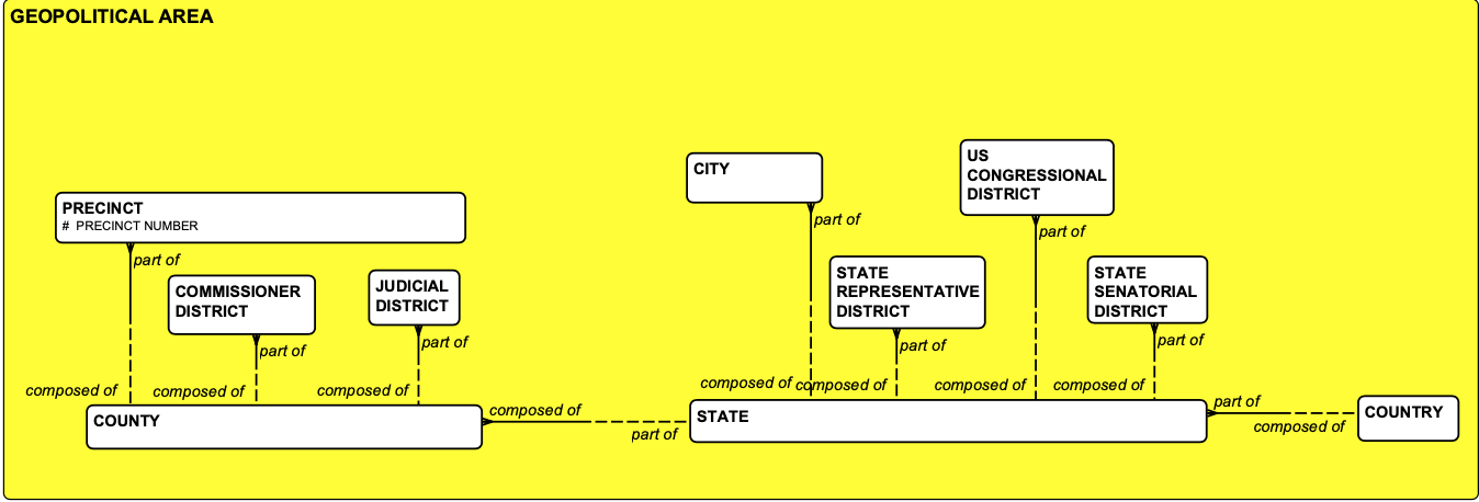
Figure 1: Geopolitical Areas
Each county may also be composed of one or more county commissioner districts and one or more Judicial districts Similarly, each State may be composed of one or more Cities, State Representative Districts, State Senatorial Districts, as well as one or more US congressional districts.
Sub-precincts
Each of the principal geopolitical areas shown in Figure 1 completely encompasses a discrete number of precincts. That is, all county commissioner districts, judicial districts, state representative districts, state senatorial districts, and US congressional districts have boundaries that encompass complete precincts. Other voting districts, however, such as School Districts and Emergency Service Districts may have boundaries that divide a precinct into multiple parts. Figure 2, then also shows that each precinct may be composed of one or more sub–precincts.
The fragments of a county or city to be included are other county districts (such as “Metropolitan Utility Districts”) and other city districts (such as School Districts).
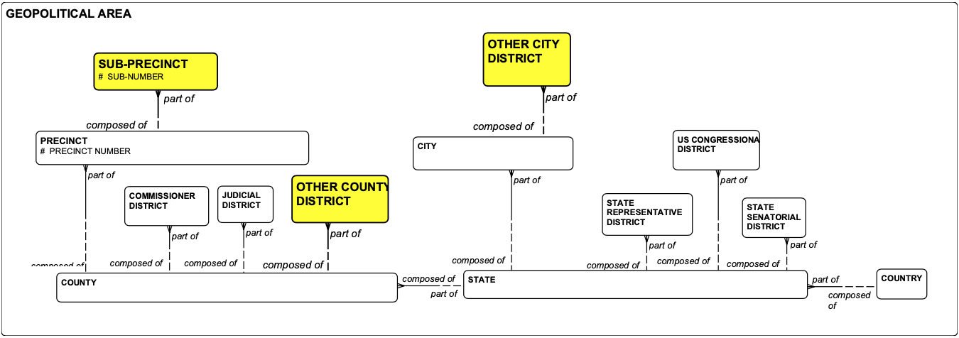
Figure 2: Sub-precincts
Precincts and Streets
There is nothing shown in Figure 2, however, that allows us to determine just which (for example) us congressional district a PRECINCT (say, 0443-“the City of Hilshire Village”) is part of. This is instead accomplished by the entity type precinct structure, introduced below in Figure 3.
Here, each precinct (or sub-precinct) may be part of one or more precinct structures, where each precinct structure, in turn, is a reference to one and only one other geopolitical area.
For example, precinct 0443 (Hilshire Village) is in fact part of a precinct structure that is a reference to us congressional district “7”. In addition, it is also part of a precinct structure that is a reference to state representative district “133”. And so forth. This is the structure required to construct any ballot for any precinct.
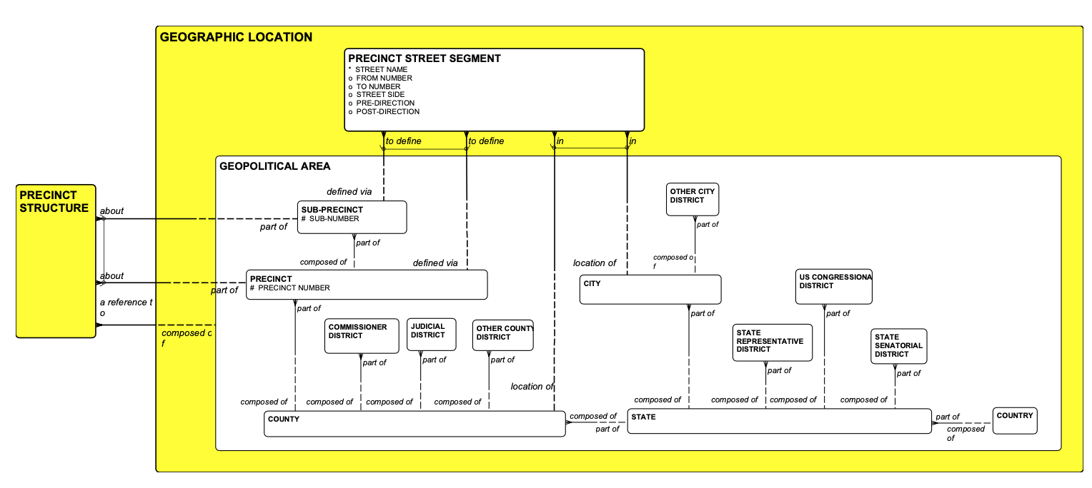
Figure 3: Precinct Structures
Additional precinct structures (again, about precinct 0443) can be a reference to:
- The county as a whole, which may have an election for “County Clerk”);
- A state representative district (“133”), which may have an election for “State Representative”,
- A state senate district (“3”), which may have an election for “State Senator”
- One of several others.
A precinct structure that is about a sub-precinct, then, would be a reference to either an
- other county district, or an
- other city district.
Also, in Figure 3 is a second sub-type of geographic area, an entity type called precinct street segment. This is the portion of a Harris county street that may be found inside a particular precinct (or sub–precinct). That is, an identified precinct street segment must be either to define a precinct or to define a sub–precinct. In addition, each precinct street segment must be either in a city or in a part of the county that is unincorporated.
Each precinct street segment must also be located in one and only one us postal area (a geographic area whose primary attribute in the USA is “ZIP” code).
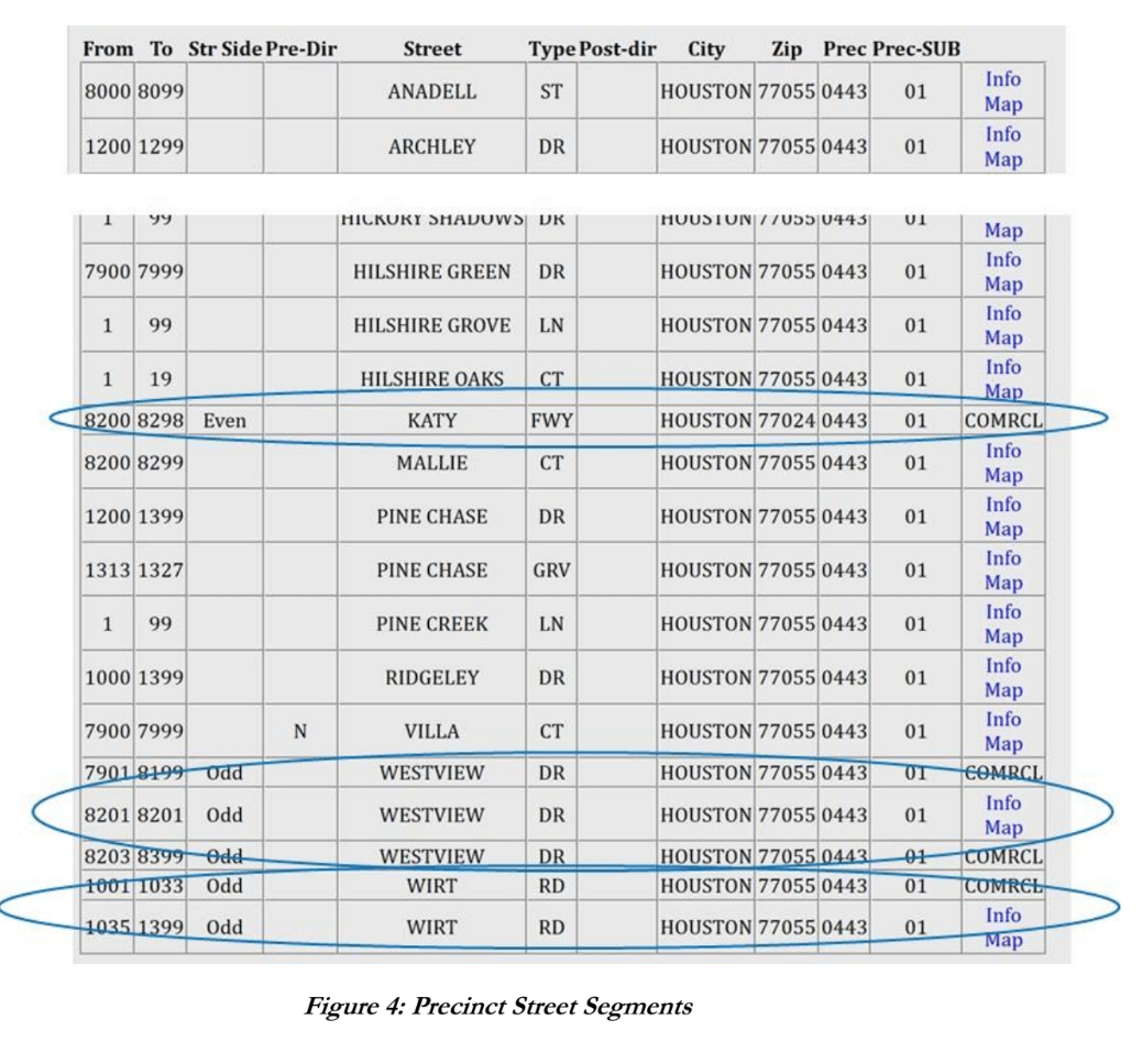
The street segments for each precinct in Harris County can be found at https://www.hctax.net/Voter/StreetGuide. You can either specify an address and find which precinct it is part of, or you can specify a precinct number and see all of the streets that define it. Figure 4 shows a portion of such a report for precinct 0443. Note that it includes boundary streets, “WESTVIEW DR”. “WIRT RD”, and “KATY FWY”.
Attributes of precinct street SEGMENT include:
- From (street number)
- To (street number)
- Str-side (side of the street – “odd” or “even”)
- Pre-dir(ection)
- Street (name)
- Post-dir(ection).
- City
- Postal area (identified by a “ZIP” code)
Note that “HILSHIRE GROVE LN” is entirely contained inside the precinct.*
The map that is Figure 5 shows the layout of precinct 0443. Note that the northernmost boundary is “WESTVIEW DR”. The precinct boundary is therefore the southern side of that street (with ODD house numbers). “WIRT RD.” Is on the east side, with the relevant addresses also being ODD-numbered. A relatively small bit of the north (EVEN-numbered) side of the “KATY FREEWAY” constitutes the southern border. The entire southwest side is not a street at all, but the Spring Branch Bayou.
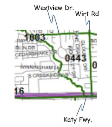
Figure 5: Map of Precinct 0443
Next Up
While this article provided the context, the next issue of this series will fill in the details:
- Voter Registrations – How each potential voter is recorded and connected to a precinct
- Candidacies – How a candidate for an office (or a ballot measure) may be shown relative to the district ‘e (or it) represents.
- Elections – How ballots are selectively defined for each precinct.
- Voting Sessions – How a vote may be recorded for each candidate (or ballot measure).
ª I should in fact have been named an “Alternative Judge”, since I was there as an alternative, to support, the “Principal Judge”. It has to do with the fact that a Republican won the last Governor’s election two years ago, so Kathy Jodeit, a Republican, is the Principal Judge for that precinct. But my official title is, alas, “Alternate Judge”. Despite that title, however, I do not “alternate” between, for example, political parties.
[1] David C. Hay. 2011. Enterprise Model Patterns: Describing the World. Technics Publications.
[1] For more on the meaning of “conceptual” models vs. other kinds of models, see your author’s 2018 book, Achieving Buzzword Compliance: Data Architecture Language and Vocabulary. Technics Publications.
§ …an abbreviation for “he or she”. Another is “h’ ” for “his or her”.
* This street, coincidentally, is the home of your author.
